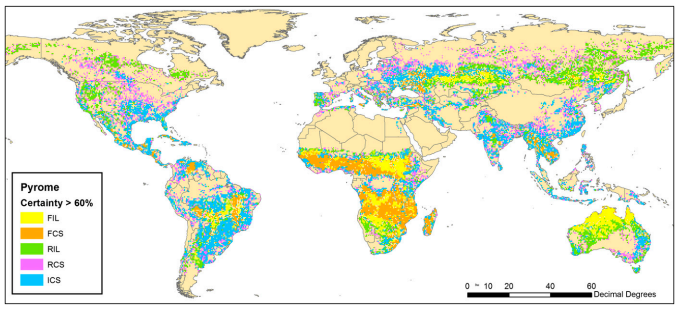
Pyromes and global fire traits (size, frequency, intensity, season)
|
Assessing how fire size, frequency, intensity, season, and extent are related to patterns of climate, vegetation (biomes), and human activity globally.
Paper: Dataset:www.dropbox.com/sh/hc3f6oi5lnyfooh/AACNY0UVEFoUqBicHAiKgtE7a?dl=0
| ||
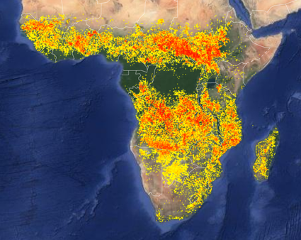
Global fire counts from MODIS MDC64A
|
Integrating spatial information on annual burnt area, fire frequency, fire seasonality, fire radiative power and fire size distributions to produce an integrated picture of fire regimes in southern Africa.
Paper: www.publish.csiro.au/wf/pdf/WF10008 Dataset: www.dropbox.com/sh/q2z2ilbqxoer945/AAAe3HQSJacMD8y0YK2L8qkfa?dl=0 Dataset: code.earthengine.google.com/1b882b030aab3fdae8f19d7d39dd03a1 |
Dataset of individual fires in Africa and their traits (size, intensity, time since last fire, season)
|
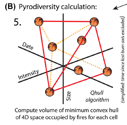
A standardised metric for quantifying pyrodiversity and exploring how environmental conditions and human activities shape pyrodiversity across Africa, and how this changes with spatial grain.
Paper: onlinelibrary.wiley.com/doi/pdf/10.1111/ecog.03109 Dataset: www.dropbox.com/sh/j788lcsxgmtdcc5/AADyzzd-RH7hp8kTCHLfv9TEa?dl=0 |
Dataset that records the number of times a 500 x 500m pixel has burned in the last 19 years (2000-2019)
Use the "inspector" tab to have a look at particular pixels of interest, and you can also change from map to satellite view by clicking the tabs on the top right of the image.
Paper:
Dataset: code.earthengine.google.com/1b882b030aab3fdae8f19d7d39dd03a1
Dataset (.tiffs): for further processing, www.dropbox.com/s/2x6tw0iloz1w4kh/AfricaFireCount2019.tif?dl=0
Paper:
Dataset: code.earthengine.google.com/1b882b030aab3fdae8f19d7d39dd03a1
Dataset (.tiffs): for further processing, www.dropbox.com/s/2x6tw0iloz1w4kh/AfricaFireCount2019.tif?dl=0
